")
")
Geophysical exploration and modeling of natural hazards
Staff: Prof. R. Di Maio, Prof. U. Riccardi, Dr. M. La Manna
PhD students: Dr. R. Buonaiuto, Dr. C. Califano, Dr. R. Casolaro
The research activity is structured along two main lines:
- Exploration of the subsurface for the study of shallow and deep geological and/or anthropogenic structures
- Modeling of natural phenomena for the assessment of hazard scenarios related to earthquakes, volcanic eruptions, hydrogeological instability, land subsidence, soil and groundwater contamination, and geothermal exploitation scenarios.
Research in the field of subsurface exploration primarily focuses on the use of geoelectrical and electromagnetic prospecting methods for the characterization of anomaly sources in various fields of application. Modeling of natural and/or anthropogenic phenomena is developed through both the integration and interpretation of multidisciplinary data and the use of numerical methods from geophysics and statistical physics.
Main research topics:
- Application of geophysical methods (including geoelectrical techniques, magnetometry, Ground Penetrating Radar – GPR, Frequency-Domain and Time-Domain Electromagnetics – FDEM and TDEM) to hydrogeological, engineering, geo-environmental and archaeological issues
- Development of innovative techniques and tools for the integrated interpretation of microgeophysical (e.g., geoelectric, GPR) and thermographic data aimed at assessing the conservation state of architectural structures
- Advancement of geophysical data inversion methods based on spectral analysis and global optimization techniques for comprehensive characterization of both single and multiple anomaly sources
- Investigation of electroseismic effects as potential precursors of seismic or volcanic events.
- Hydrogeophysical modeling for the assessment of soil and groundwater contamination and for simulating fluid migration in the subsurface
- Derivation of velocity and attenuation models from seismic noise recordings in volcanic environments
- Modeling and monitoring of ground surface deformation through the integration of geodetic (GNSS, InSAR), geological, hydrological and climatic data.
- Modelling and monitoring of temporal gravity changes in active volcanic and geothermal areas using hybrid gravimetry techniques, i.e. through the integration of discrete relative and absolute gravimetric measurements and continuous recordings.
- Modeling and thermo-fluid dynamic simulation of hydrothermal and geothermal systems using continuous geoelectrical, magnetotelluric and gravity measurements.
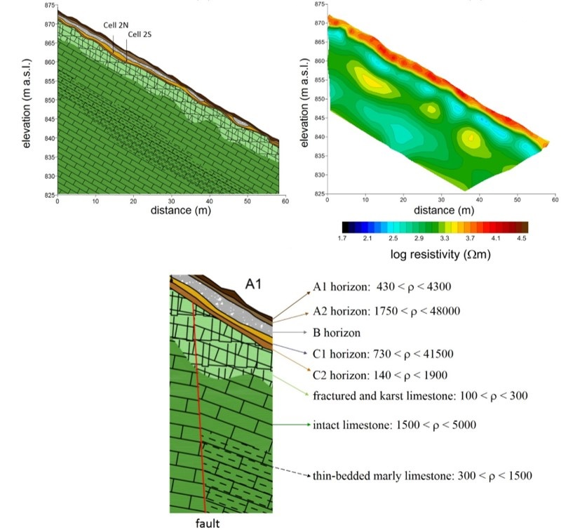
Geological cross section reconstructed from geoelectrical surveys carried out on Mt. Faito (Naples, Italy) along a slope prone to debris-flow events.
 Simulation of CO₂ degassing along an active fault zone.
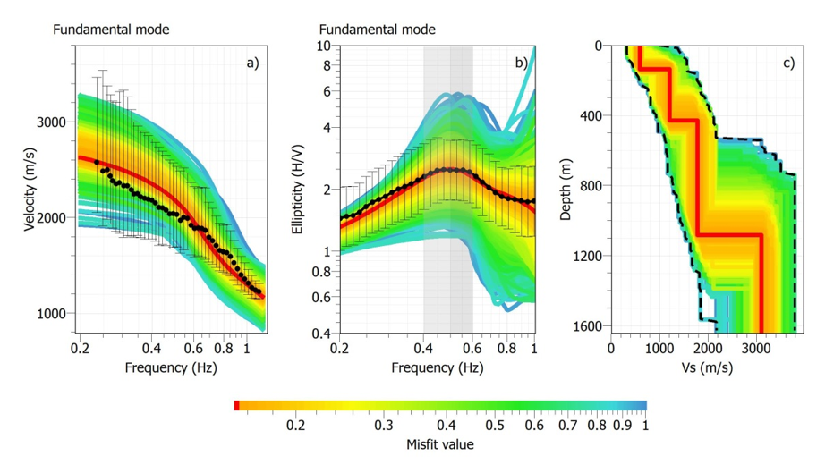
1D seismic velocity model of the Ischia Island (Naples, Italy) derived from the diffuse wavefield of ambient seismic noise (c). Results of joint inversion of dispersion curves (a) and average H/V spectral ratio (b).
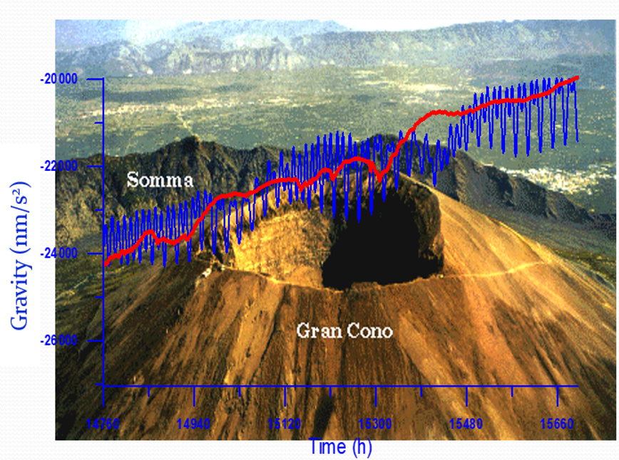 Gravity record (blue curve) collected on Mt. Vesuvius (Naples, Italy) and residual gravity change (red curve) after removal of gravity signal due to tides and meteo-marine effects
 Hybrid gravimetry for geothermal reservoir monitoring
 (a) Morpho-structural map of the island of Vulcano. (b) Thermo-fluid dynamic simulation results: N-S and E-W cross-sections showing simulated temperature (top) and CO2 partial pressure (bottom) distributions.
Main National Collaborations:
- Dipartimento di Ingegneria Civile, Edile e Ambientale, Università di Padova
- Dipartimento di Ingegneria, Università di Perugia
- Dipartimento di Fisica “Ettore Pancini”, Università di Napoli Federico II
- Dipartimento di Ingegneria Civile, Edile e Ambientale, Università di Napoli Federico II
- Istituto Nazionale di Geofisica e Vulcanologia (INGV), Sezione di Roma
- INGV, Osservatorio Vesuviano, Sezione di Napoli
- INGV, Sezione di Grottaminarda
- Istituto Superiore per la protezione e la Ricerca Ambientale (ISPRA), Roma
Main International Collaborations:
- Department of Environmental and Natural Resources Engineering, Technological Educational Institute of Crete, Chania, Crete, Greece
- School of Environmental Engineering, Technical University of Crete, Crete, Greece
- Department of Earthquake Engineering, Tarbiat Modares University, Tehran, Iran
- Department of Geophysics, Faculty of Science, Cairo University, Giza, Egypt
- Institute of Earth Sciences, The Hebrew University of Jerusalem, Jerusalem, Israel
- École et Observatoire de Sciences de la Terre, University of Strasbourg, France
- Institute de Physique du Globe, Strasbourg, France
- Grupo de Investigación Geodesia de la Universidad Complutense de Madrid, Madrid, Spain
- GFZ German Research Centre for Geosciences, Potsdam, Germany