Research areas

Seismic microzonation

Staff: Prof. Domenico Calcaterra, Prof. Paola Petrosino, Prof. Diego Di Martire, Prof. Giacomo Russo, Dott. Maurizio Milano, Prof. Pantaleone De Vita, Dott. Luigi Guerriero, Prof. Luigi Ferranti, Prof. Stefano Vitale, Dott. Mauro La Manna, Dott. Enza Vitale, Prof. Maurizio Fedi, Prof. Giovanni Florio, Prof. Valeria Paoletti, Prof. Vincenzo Allocca, Dott. Francesco Iezzi, Dott. Francesco Pavano


The research activity is structured along four main lines:

  • Structural and geotechnical modelling of the subsurface
  • Geophysical surveys
  • Geotechnical characterisation of soils and rocks
  • Earthquake-induced instabilities

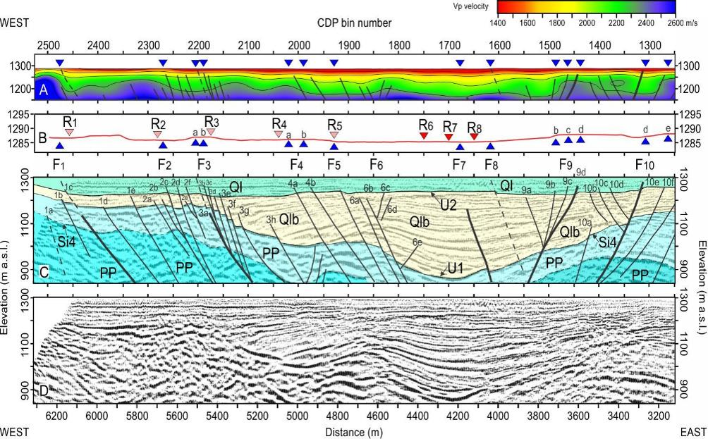
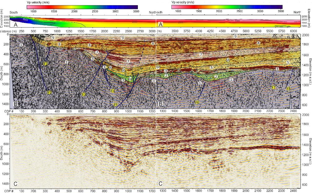
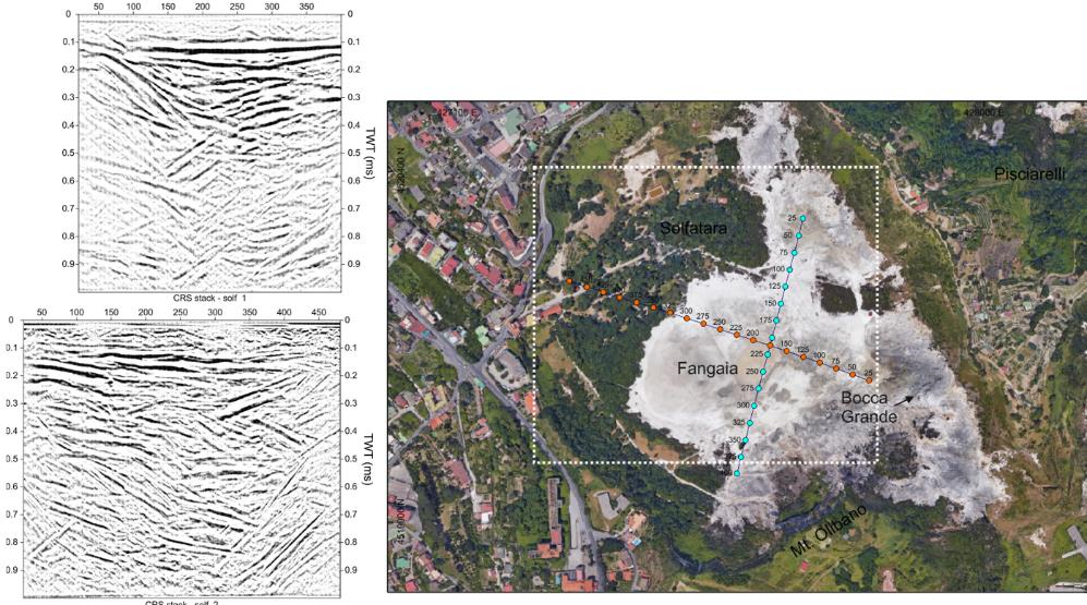
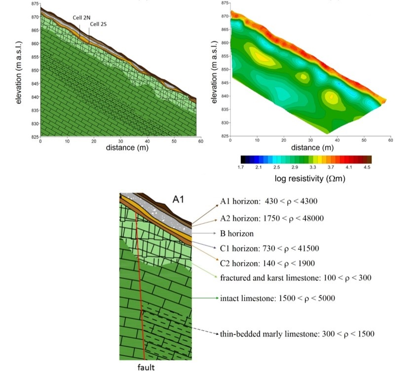
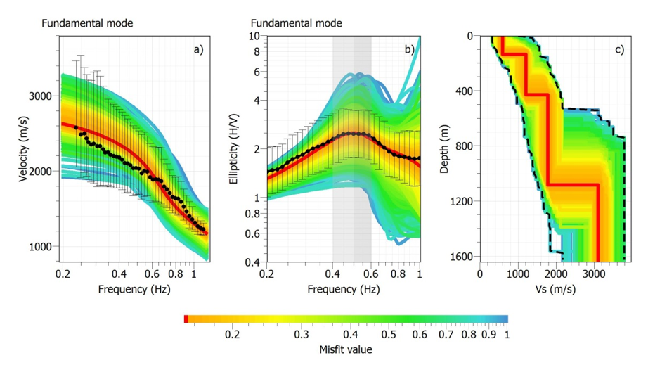
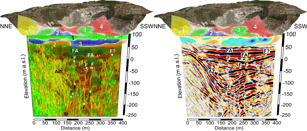
 As far as subsurface modelling is concerned, research activities mainly focus on 2D and 3D reconstruction, based on survey campaigns, using specialised application software. With regard to geophysical surveys, the activity concerns the application of geoelectrical, electromagnetic and microgravimetric prospecting methods. Geotechnical characterisation is developed through tests conducted at the Applied Geology and Geotechnical Laboratory of the Department of Earth, Environmental and Resource Sciences. The topic of earthquake-induced instabilities includes the study of cavities, active and capable faults and earthquake-induced landslide phenomena.

microzonazione sismica2

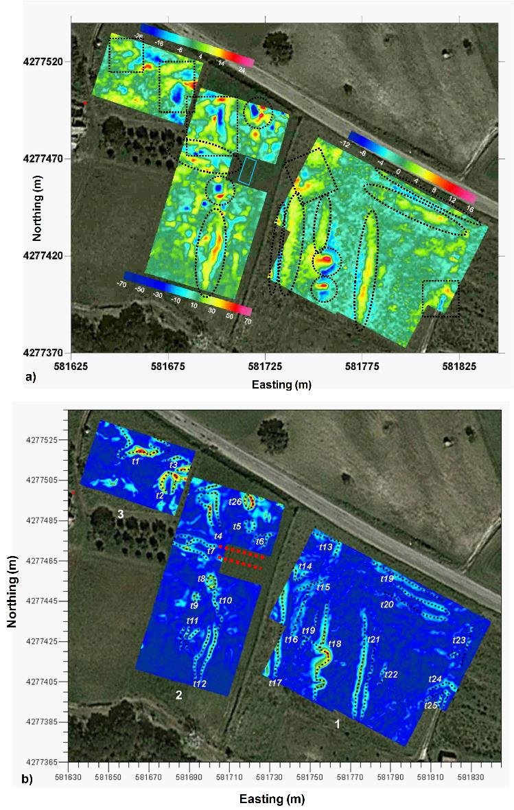
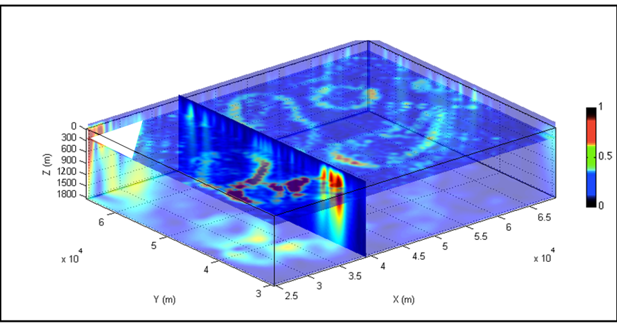
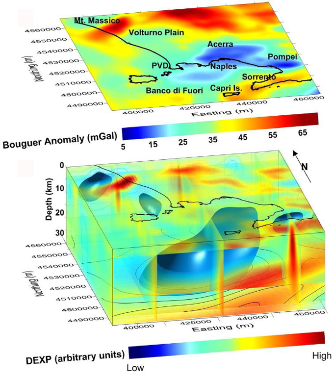
Figure – Map of Terrain-UnCorrelated Anomalies (TUCA). The letter A indicates the gravimetric anomaly detected.

Main national collaborations:

  • Dipartimento di Protezione Civile – Presidenza del Consiglio dei Ministri
  • Dipartimento di Ingegneria Civile, Edile e Ambientale, Università di Napoli Federico II
  • Istituto Nazionale di Geofisica e Vulcanologia (INGV), Sezione Osservatorio Vesuviano
  • INGV, Osservatorio Vesuviano, Sezione di Napoli
  • INGV, Sezione di Grottaminarda
  • Consiglio Nazionale delle Ricerche - Istituto di Geologia Ambientale e Geoingegneria (IGAG)
  • Istituto Superiore per la protezione e la Ricerca Ambientale (ISPRA), Roma
  • Consiglio Nazionale delle Ricerche - Istituto di Metodologie per l'Analisi Ambientale (IMAA)
  • Consiglio Nazionale delle Ricerche - Istituto di Scienze del Patrimonio Culturale (ISPC)

Geophysical surveys for environment and geologic investigations

Post- Graduates: Mauro La Manna, Anna Giuseppa Cicchella, Luigi Bianco, Lorenzo Ricciardi, Angelica Capozzoli, Ciro Messina. 
 

This research line is based on our 20-year-old expertise in geophysical surveys and data modelling in many different geological settings; the main research lines are listed in more detail below. The techniques used for data analysis and interpretation have been presented and published by our research group in many international meetings and on top journals.

  • Geophysics for the geothermy: evaluation of the geothermic potential based on hydrological and temperature data; evaluation of the depth of the carbonate basement with seismic, gravimetric and magnetometry methods; evaluation of the patterns of the Curie isotherm for geothermal studies.
  • Geophysical characterization of the crust: crust modeling (magnetometric/gravity satellite and airborne surveys, at continental scale);
  • Geophysics for seismo-tectonic analysis: acquisition, processing and integrated analysis of active seismic, seismological, gravity, deformation and geo-structural data for identification and characterization of active faults in seismogenic areas (Figs. 1,2);
  • Geophysics for volcanological studies: airborne (magnetometric, EM and gamma-ray, active seismic) surveys in volcanic areas; characterization of the structural features of volcanic areas ( 3).
  • Environmental geophysics: surveys on iron deposits, landfill percolate, metallic drums, UXO (magnetometric method, GPR, FDEM, EM, resistivity);
  • Engineering geophysics: surveys for and on civil engineering works (microgravimetry, magnetometric and geoelectrical methods, GPR, FDEM; seismic reflection and refraction);
  • Mining geophysics: surveying and modeling of mining deposits, the target is their localization; physical characterization including total mass and remanent magnetization estimation;
  • Archaeogeophysics: geophysical investigations on buried archaeological structures and cultural heritage monuments and building (magnetometric and geoelectrical methods, GPR, FDEM, gravity) ( 4).
imaging geofisico2

Fig. 1. Results of Vp refraction tomography and seismic reflection surveying along the western portion of the Hansel Valley Basin (USA) basin. Black triangles indicate the surface projection of interpreted faults; dark-gray triangles show the location of the surface ruptures associated with the 1934, M 6.6 earthquake and intersecting the seismic profile. Light-gray triangles are surface ruptures projected on the seismic line (Bruno et al., 2017).


imaging geofisico

Fig. 2. Details of the southern part of Price Creek's refraction tomographic profile (A) and of the seismic reflection line in which the coherence attribute and the energy attribute are superimposed to the seismic amplitudes (B). The structural and stratigraphic interpretation is also reported in (B). Uninterpreted data is shown in (C) (Bruno et al., 2019)

imaging geofisico3

Fig. 3.  The shallow structure of the Solfatara volcano, in Italy, from wide-aperture reflection seismic profiles (Bruno et al., 2017).


imaging geofisico4

Fig. 4.  (a) Vertical gradient of the magnetic anomaly field after reduction to the pole at the archaeological site of Torre Galli (Vibo Valentia). Dotted lines show the main patterns of anomalies. Light blue rectangle is the area of archaeological excavation before the geophysical survey. (b) Edge analysis of magnetometry data through the EHD method. Edges of the buried sources are identified by local maxima; the red dashed lines show structures unearthed during a previous excavation (Cella and Fedi 2015).

Projects

Research project DISTAR-ENI: Development of Machine Learning techniques applied to potential fields.


National Collaborations:

- Istituto Nazionale di Oceanografia e di Geofisica Sperimentale (OGS), Trieste

- Istituto Nazionale di Geofisica e Vulcanologia (INGV), Sections of Catania, Rome; Naples

- Osservatorio Vesuviano (OV), INGV Sezione di Napoli

- Università degli Studi della Calabria (UNICAL), Cosenza

- Università degli Studi Suor Orsola Benincasa, Naples

- Università del Salento, Lecce

- Università degli Studi di Camerino

- Dipartimento di Matematica e Geoscienze, Università di Trieste

- Dipartimento di Ingegneria Civile, Ambientale e Architettura, Università di  

   Cagliari

- C.N.R., Section of Pisa

- C.N.R., IREA- Istituto per il Rilevamento Elettronico dell'Ambiente, Naples

- C.N.R., ISMAR- Istituto DI Scienze Marine, Naples

- INNOVA – Scarl, Naples

- Dipartimento di Studi Umanistici, Università Federico II, Naples

- Dipartimento di Ingegneria Industriale, Università Federico II, Naples

- Dipartimento di Fisica “Ettore Pancini”, Naples

International Collaborations:

- The University of Utah (USA)

- The Khalifa University, Abu Dhabi (UAE)

- The United States Geological Survey-USGS (USA)

- The Leigh University, Bethlehem, PA 18015 (USA)

- The Idaho Geological Survey, Moscow, ID 83844 (USA)

- The University of Patras (Greece)

- Geological Survey of Austria (GSA), Vienna (Austria)

- Institute of Sciences and High Technologies and Environmental Sciences, Kerman (Iran)

- The Aristotle University of Thessaloniki (Greece)

Imaging and inversion of geophysical data

Staff: Pier Paolo Bruno, Maurizio Fedi, Giovanni Florio, Valeria PaolettiMaurizio Milano, Mahmoud Abbas

Post - Graduates: Mauro La Manna, Anna Giuseppa Cicchella, Luigi Bianco, Lorenzo Ricciardi, Angelica Capozzoli, Ciro Messina. 

This research topic focuses on the joint interpretation and/or inversion of large, multivariate geophysical datasets, a key issue for oil industry and for reduction of geological hazards. For this task we employ machine-learning techniques; 3D inversion algorithms and fast imaging methods. Our commitment to this interesting field dates back to the 90s, and at present we continue our involvement with active collaborations with industry (ENI) and other Universities (such as DTU, Denmark) and by developing new algorithms that are aimed at retrieving the underground distribution of source parameters, such as the P-wave and S-wave velocity, density, magnetic susceptibility and electrical resistivity. Details of all research themes falling within this research topic are listed below.

Development of original interpretation tools and software:

 Continuous and discrete wavelet transform; multi-resolution analysis applied to the local residuation of potential fields; 

  • Multidimensional spectral analysis;
  • Multiscale methods for automatic estimation of parameters of potential field, deformation field and low-frequency EM sources;
  • Edge analysis of geophysical data;
  • Fractal and multi-fractal analysis of geophysical data;
  • Imaging of potential fields: migration, DEXP and correlation algorithms ( 1-2);
  • Large-scale methods of 2D and 3D linear and non-linear (constrained) inversion of gravity, seismic, magnetic and resistivity data, such as: Inversion of Inhomogeneous potential fields, Self-constrained Inversion and Focusing, joint inversion of geophysical data, tools for monitoring the retrievable depth-resolution in potential-field interpretation (Depth Resolution Plot).
  • Machine Learning methods for modeling and interpretation of multivariate geophysical data ( 3).
  • Imaging of CSEM data;

 invers geof

Fig. 1. Depth analysis on diapirs in Nordkapp basin by DEXP (Fedi & Pilkington, 2012) applied to magnetic data (Fedi, Florio & Paoletti, 2014).


invers geof2

Fig. 2. Interpretation of the Gravity field of the Campania Active Volcanic Area: Upper plot: Gravity anomaly map. Lower plot: DEXP image of the sources of the anomalies (Fedi et al., 2018).


invers geof3 

Fig. 3. Comparison between the results obtained from K-means and SOM algorithms on three geophysical datasets acquired in the Solfatara Crater (left) and the original seismic reflection and electric tomography data (right). Symbol explanations. F: fault/fracture (also highlighted by vertical arrows); AZ: anomalous zone; FA: fluid accumulation; IB: intrusive body (Bernardinetti & Bruno, 2019).

Projects

Research project DISTAR-ENI: Development of Machine Learning techniques applied to potential fields.


National Collaborations:

- Istituto Nazionale di Geofisica e Vulcanologia (INGV), Sections of Catania, Naples and Rome

- Osservatorio Vesuviano (OV), INGV Sezione di Napoli

- Università degli Studi della Calabria (UNICAL), Cosenza

- Università del Salento, Lecce

- Università degli Studi di Camerino

- Centro di Geotecnologie, Università degli Studi di Siena, S. Giovanni Valdarno (Arezzo)

- C.N.R., IREA- Istituto per il Rilevamento Elettronico dell'Ambiente, Naples

- C.N.R., ISMAR- Istituto DI Scienze Marine, Naples

- ENI, San Donato Milanese, Milan

- Università degli Studi di Cagliari


International Collaborations:

- The Comenius University in Bratislava, Slovakia

 -The University of the Witwatersrand, Johannesburg, South Africa

- The South Valley University, Qena, Egypt

- The Danish Technical University (DTU), Lyngby, Denmark

- Geological Survey of Canada (GSC), Ottawa

- Institute of Sciences and High Technologies and Environmental Sciences, Kerman, Iran

- Getech, Leeds, UK

- National Geophysical Research Institute (NGRI), Hyderabad, India

- The Aarhus University, Denmark

-Aristotle University of Thessaloniki, Grecia


Geophysical exploration and modeling of natural hazards

 Staff: Prof. R. Di Maio, Prof. U. Riccardi, Dr. M. La Manna

PhD students: Dr. R. Buonaiuto, Dr. C. Califano, Dr. R. Casolaro

The research activity is structured along two main lines:

  • Exploration of the subsurface for the study of shallow and deep geological and/or anthropogenic structures
  • Modeling of natural phenomena for the assessment of hazard scenarios related to earthquakes, volcanic eruptions, hydrogeological instability, land subsidence, soil and groundwater contamination, and geothermal exploitation scenarios.

 Research in the field of subsurface exploration primarily focuses on the use of geoelectrical and electromagnetic prospecting methods for the characterization of anomaly sources in various fields of application. Modeling of natural and/or anthropogenic phenomena is developed through both the integration and interpretation of multidisciplinary data and the use of numerical methods from geophysics and statistical physics.


Main research topics:

  • Application of geophysical methods (including geoelectrical techniques, magnetometry, Ground Penetrating Radar – GPR, Frequency-Domain and Time-Domain Electromagnetics – FDEM and TDEM) to hydrogeological, engineering, geo-environmental and archaeological issues
  • Development of innovative techniques and tools for the integrated interpretation of microgeophysical (e.g., geoelectric, GPR) and thermographic data aimed at assessing the conservation state of architectural structures
  • Advancement of geophysical data inversion methods based on spectral analysis and global optimization techniques for comprehensive characterization of both single and multiple anomaly sources
  • Investigation of electroseismic effects as potential precursors of seismic or volcanic events.
  • Hydrogeophysical modeling for the assessment of soil and groundwater contamination and for simulating fluid migration in the subsurface
  • Derivation of velocity and attenuation models from seismic noise recordings in volcanic environments
  • Modeling and monitoring of ground surface deformation through the integration of geodetic (GNSS, InSAR), geological, hydrological and climatic data.
  • Modelling and monitoring of temporal gravity changes in active volcanic and geothermal areas using hybrid gravimetry techniques, i.e. through the integration of discrete relative and absolute gravimetric measurements and continuous recordings.
  • Modeling and thermo-fluid dynamic simulation of hydrothermal and geothermal systems using continuous geoelectrical, magnetotelluric and gravity measurements.


esplor geof2

Geological cross section reconstructed from geoelectrical surveys carried out on Mt. Faito (Naples, Italy) along a slope prone to debris-flow events.


risalita CO2Simulation of CO₂ degassing along an active fault zone.


esplor geof4

1D seismic velocity model of the Ischia Island (Naples, Italy) derived from the diffuse wavefield of ambient seismic noise (c). Results of joint inversion of dispersion curves (a) and average H/V spectral ratio (b).


esplor geof6Gravity record (blue curve) collected on Mt. Vesuvius (Naples, Italy) and residual gravity change (red curve) after removal of gravity signal due to tides and meteo-marine effects

  gravimetria ibridaHybrid gravimetry for geothermal reservoir monitoring

 isola di vulcano(a) Morpho-structural map of the island of Vulcano. (b) Thermo-fluid dynamic simulation results: N-S and E-W cross-sections showing simulated temperature (top) and CO2 partial pressure (bottom) distributions.
 

Main National Collaborations:

  • Dipartimento di Ingegneria Civile, Edile e Ambientale, Università di Padova
  • Dipartimento di Ingegneria, Università di Perugia
  • Dipartimento di Fisica “Ettore Pancini”, Università di Napoli Federico II
  • Dipartimento di Ingegneria Civile, Edile e Ambientale, Università di Napoli Federico II
  • Istituto Nazionale di Geofisica e Vulcanologia (INGV), Sezione di Roma
  • INGV, Osservatorio Vesuviano, Sezione di Napoli
  • INGV, Sezione di Grottaminarda
  • Istituto Superiore per la protezione e la Ricerca Ambientale (ISPRA), Roma

Main International Collaborations:

  • Department of Environmental and Natural Resources Engineering, Technological Educational Institute of Crete, Chania, Crete, Greece
  • School of Environmental Engineering, Technical University of Crete, Crete, Greece
  • Department of Earthquake Engineering, Tarbiat Modares University, Tehran, Iran
  • Department of Geophysics, Faculty of Science, Cairo University, Giza, Egypt
  • Institute of Earth Sciences, The Hebrew University of Jerusalem, Jerusalem, Israel
  • École et Observatoire de Sciences de la Terre, University of Strasbourg, France
  • Institute de Physique du Globe, Strasbourg, France
  • Grupo de Investigación Geodesia de la Universidad Complutense de Madrid, Madrid, Spain
  • GFZ German Research Centre for Geosciences, Potsdam, Germany


Archaeometry and Cultural Heritage

Staff: Giuseppina Balassone, Piergiulio Cappelletti, Abner Colella, Alberto De Bonis, Claudia Di Benedetto, Vincenza Guarino, Francesco Izzo, Alessio Langella, Vincenzo Morra, Concetta Rispoli

Collaborators (permanent): Sossio Fabio Graziano (Dipartimento di Farmacia - UniNA)

Collaborators (non permanent): Francesco D’Uva (post-doc UniOR), Martina Mercurio (PhD DiSTAR – XL ciclo), Giovanna Montesano (post-doc UniCH), Michela Scanu (PhD DiSTAR – XL cycle), Serena Spadavecchia (national PhD in Heritage Science - XXXIX cycle), Maria Verde (post-doc DiARC - UniNA)


Archaeometry, or Archaeological Science, is the application of scientific techniques to the analysis of archaeological and Cultural Heritage materials. Geological methods, and mineralogical-petrographic techniques in particular, are those that best serve to obtain information on provenance and technological features of archaeological items made from geological resources. This multidisciplinary approach provides useful data on the state of the geomaterials used in the Cultural Heritage in order to assess their degradation and better plan conservation and restoration interventions. The research is also made in close cooperation with archaeologists with the aim of reconstructing the exchanges between ancient civilisations and evaluating their technological development.

Archaeometric investigations are carried out by means of a multi-analytical approach with the instruments available at the DiSTAR

See the website of the CRACS (Center for Research on Archaeometry and Conservation Science) for further information

Ceramics

The mineralogical-petrographic approach is commonly used to find the provenance of pottery via the comparison with the raw materials composition and with the geological features of the territory. Furthermore, it is possible to reconstruct the production technologies of ceramics, from the preparation of the mixtures and coatings to firing dynamics (temperature, atmosphere). The research team at the DiSTAR has gained experience by investigating various ceramic classes (table ware, cooking ware, amphorae, bricks, etc.) of different periods and provenance. In particular, from Campanian archaeological sites (Cumae, Neapolis, Pompeii, Paestum, etc.), but also from other locations in Italy and abroad (Asia, Africa).

Mortars and plasters

An important part of the research is aimed at the study of geomaterials used as a binder (mortars and concretes), with a particular focus on those of the Roman age in the Campanian context. Important data on raw material sources and their circulation can be obtained, along with the knowledge of the ancient production technologies. This can be a starting point for the production of new types of binders and mortars, by studying the formation processes of the new different mineral components. Furthermore, it is possible to recognise possible different building phases, evaluate the degradation and formulate mixtures useful for restoration compatible with the materials in use and the environmental conditions.

Building and ornamental stones

The research is mainly focused on the study of the ornamental stones of the historic buildings, also in order to plan a possible reuse of the ancient quarries and promote the different lithotypes. The activity is carried out in collaboration with experts in the history of architecture and restoration to improve knowledge of the stones used in the Cultural Heritage, interpreting the degradation processes and drawing up a  long-lasting conservation plan. An important role is played by integrated diagnostics for interpreting the historical architecture and guiding the intervention.

Metals

The archaeometric investigation of ancient metals from the Mediterranean area (Bronze Age, Iron Age, Orientalising, etc.) performed at the DiSTAR mainly concern the mineralogical and petrographic characterisation of these objects. The research is also aimed at the eventual recovery and conservation of metal artefacts and at the study of the raw materials sources from the different metal deposits, by means of mineralogical-geochemical analysis (minor elements and traces, isotopic analysis, etc.).

Paintings

The archaeometric analyses on paintings are used to identify the substances used as pigments and their production techniques. A particular role is that of nondestructive testing, useful for making analyses without taking samples and altering the investigated material.


Main collaborations

Museo Archeologico Nazionale di Napoli

Parco Archeologico di Pompei

Soprintendenza Archeologia, Belle Arti e Paesaggio per il comune di Napoli

Soprintendenza Archeologia, Belle Arti e Paesaggio per l'Area Metropolitana di Napoli

Parco Archeologico Campi Flegrei

Centre Jean Bérard, unità del Centre National de la Recherche Scientifique (CNRS), France

Università degli Studi di Napoli L'Orientale – Dipartimento Asia, Africa e Mediterraneo

Università del Sannio – Dipartimento di Scienze e Tecnologie

University of Missouri Research Reactor Center, USA


Archaeometry and Cultural Heritage
 
 
logoUniNa   
scuola psb
universitaly

Where we are

  whatsapp

Find us

  Find us on Google Map

Newsletter subscription