")
")
Geophysical surveys for environment and geologic investigations
This research line is based on our 20-year-old expertise in geophysical surveys and data modelling in many different geological settings; the main research lines are listed in more detail below. The techniques used for data analysis and interpretation have been presented and published by our research group in many international meetings and on top journals.
- Geophysics for the geothermy: evaluation of the geothermic potential based on hydrological and temperature data; evaluation of the depth of the carbonate basement with seismic, gravimetric and magnetometry methods; evaluation of the patterns of the Curie isotherm for geothermal studies.
- Geophysical characterization of the crust: crust modeling (magnetometric/gravity satellite and airborne surveys, at continental scale);
- Geophysics for seismo-tectonic analysis: acquisition, processing and integrated analysis of active seismic, seismological, gravity, deformation and geo-structural data for identification and characterization of active faults in seismogenic areas (Figs. 1,2);
- Geophysics for volcanological studies: airborne (magnetometric, EM and gamma-ray, active seismic) surveys in volcanic areas; characterization of the structural features of volcanic areas ( 3).
- Environmental geophysics: surveys on iron deposits, landfill percolate, metallic drums, UXO (magnetometric method, GPR, FDEM, EM, resistivity);
- Engineering geophysics: surveys for and on civil engineering works (microgravimetry, magnetometric and geoelectrical methods, GPR, FDEM; seismic reflection and refraction);
- Mining geophysics: surveying and modeling of mining deposits, the target is their localization; physical characterization including total mass and remanent magnetization estimation;
- Archaeogeophysics: geophysical investigations on buried archaeological structures and cultural heritage monuments and building (magnetometric and geoelectrical methods, GPR, FDEM, gravity) ( 4).
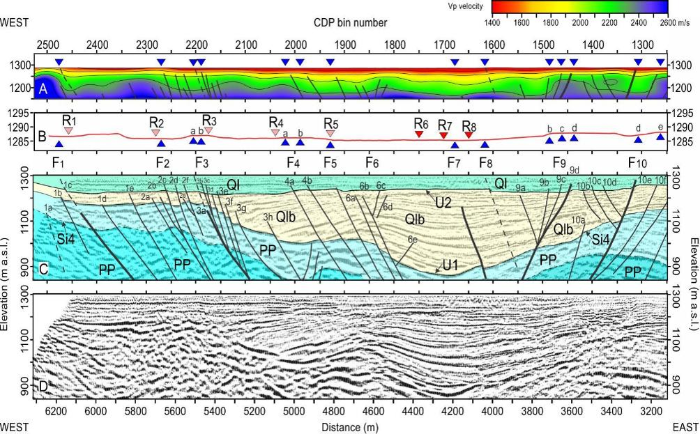
Fig. 1. Results of Vp refraction tomography and seismic reflection surveying along the western portion of the Hansel Valley Basin (USA) basin. Black triangles indicate the surface projection of interpreted faults; dark-gray triangles show the location of the surface ruptures associated with the 1934, M 6.6 earthquake and intersecting the seismic profile. Light-gray triangles are surface ruptures projected on the seismic line (Bruno et al., 2017).
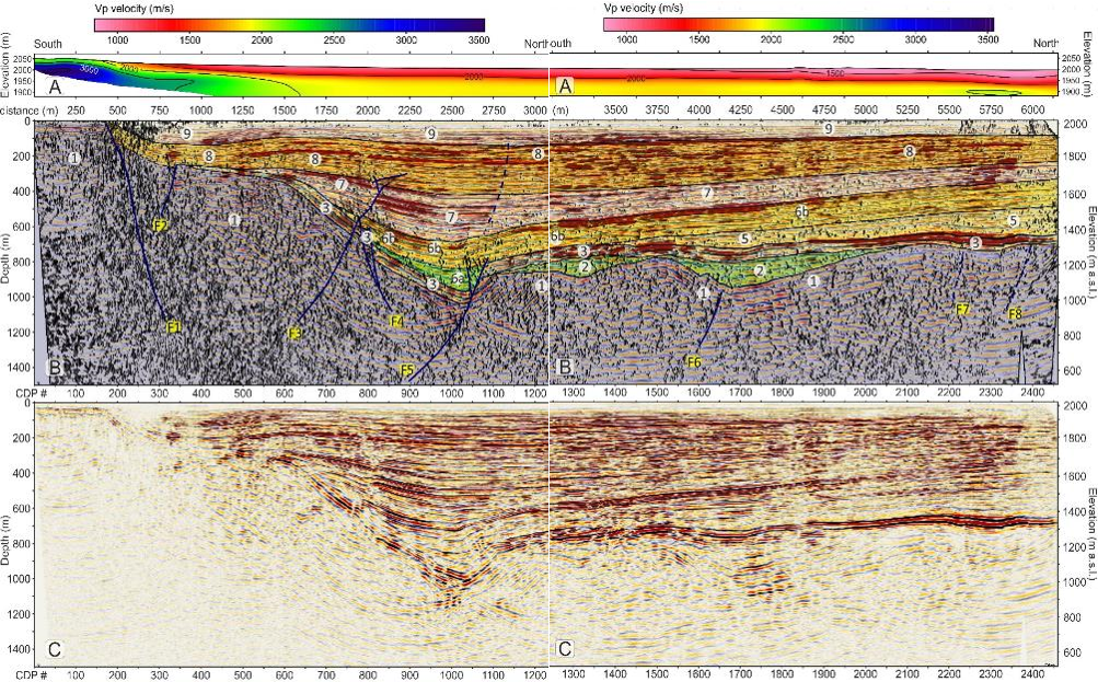
Fig. 2. Details of the southern part of Price Creek's refraction tomographic profile (A) and of the seismic reflection line in which the coherence attribute and the energy attribute are superimposed to the seismic amplitudes (B). The structural and stratigraphic interpretation is also reported in (B). Uninterpreted data is shown in (C) (Bruno et al., 2019)
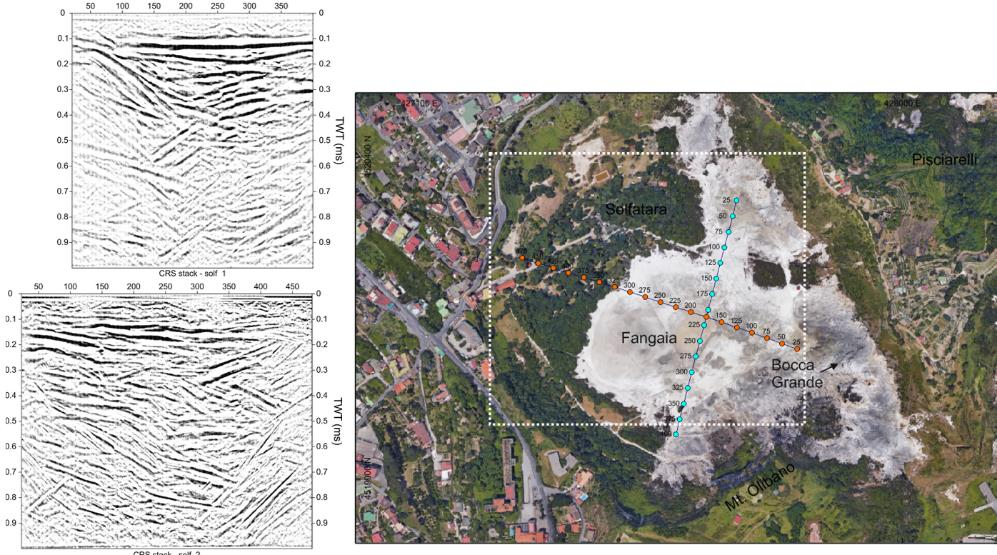
Fig. 3. The shallow structure of the Solfatara volcano, in Italy, from wide-aperture reflection seismic profiles (Bruno et al., 2017).
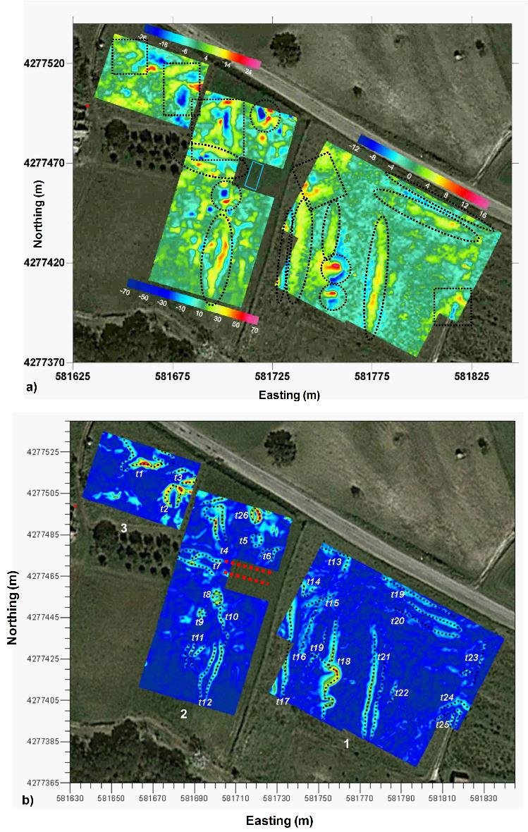
Fig. 4. (a) Vertical gradient of the magnetic anomaly field after reduction to the pole at the archaeological site of Torre Galli (Vibo Valentia). Dotted lines show the main patterns of anomalies. Light blue rectangle is the area of archaeological excavation before the geophysical survey. (b) Edge analysis of magnetometry data through the EHD method. Edges of the buried sources are identified by local maxima; the red dashed lines show structures unearthed during a previous excavation (Cella and Fedi 2015).
Projects
Research project DISTAR-ENI: Development of Machine Learning techniques applied to potential fields.
National Collaborations:
- Istituto Nazionale di Oceanografia e di Geofisica Sperimentale (OGS), Trieste
- Istituto Nazionale di Geofisica e Vulcanologia (INGV), Sections of Catania, Rome; Naples
- Osservatorio Vesuviano (OV), INGV Sezione di Napoli
- Università degli Studi della Calabria (UNICAL), Cosenza
- Università degli Studi Suor Orsola Benincasa, Naples
- Università del Salento, Lecce
- Università degli Studi di Camerino
- Dipartimento di Matematica e Geoscienze, Università di Trieste
- Dipartimento di Ingegneria Civile, Ambientale e Architettura, Università di
Cagliari
- C.N.R., Section of Pisa
- C.N.R., IREA- Istituto per il Rilevamento Elettronico dell'Ambiente, Naples
- C.N.R., ISMAR- Istituto DI Scienze Marine, Naples
- INNOVA – Scarl, Naples
- Dipartimento di Studi Umanistici, Università Federico II, Naples
- Dipartimento di Ingegneria Industriale, Università Federico II, Naples
- Dipartimento di Fisica “Ettore Pancini”, Naples
International Collaborations:
- The University of Utah (USA)
- The Khalifa University, Abu Dhabi (UAE)
- The United States Geological Survey-USGS (USA)
- The Leigh University, Bethlehem, PA 18015 (USA)
- The Idaho Geological Survey, Moscow, ID 83844 (USA)
- The University of Patras (Greece)
- Geological Survey of Austria (GSA), Vienna (Austria)
- Institute of Sciences and High Technologies and Environmental Sciences, Kerman (Iran)
- The Aristotle University of Thessaloniki (Greece)